Archive for the ‘Google Maps’ Category

ClassyGMaps

Wednesday, April 29th, 2015

In the time honoured tradition, of kinda resurrecting closed down Google products, heres another..

ClassyGMaps

Its the start of an attempt to recreate Classic Google Maps. But not far beyond a prototype yet.

It can already display KML files, split screen streetview, and 45-degree aerial imagery, three things lost in ‘New Maps’.

Its on GitHub:
https://github.com/barryhunter/classygmaps/

and has its own issue tracker:
https://github.com/barryhunter/classygmaps/issues

If want it to develop, post your requests!

Update: Added two new map types, a live emulation of UK road colour scheme (works worldwide!), and access to legacy map tiles, from before Google changed the colour scheme. I dont think the tiles will be updated to include new roads etc, but might be interesting to get a decent colour scheme.

Preservation of the Google Maps Directory

Saturday, December 18th, 2010

Recently Google deprecated Mapplets, which are little applications that ran on Google Maps. They have also now removed the Google Maps Directory.

However its still possible to run mapplets by a dedicated page (well at least for as long as V2 of the Google Maps API exists) – but no listing of mapplets available within Google Maps.


But fear not, I captured a copy of the mapplet list, and created a small crawler to fetch the details from the mapplets, and present them in a little searchable application:

Replacement Mapplet Directory

Admittedly the quality of the applications in the directory where always kinda variable, but there is some real gems in there, so at least preserving a listing I think is worthwhile, so they can be accessed if needbe.

Google Earth should make the sea floor rendering optional?

Monday, July 5th, 2010

Way back when, I wrote a rather scathing review of the then new “sea floor” imagery. This takes the form of a rendering supposed to represent the ’3Dness’ of the sea floor, persumably to improve the feel when exploring under the water surface.

Indeed it would look off, to ‘fly’ under the sea, and then see surface imagry projected onto the both bottom.

Alas that comes at a high price, namely that this imagery is ‘allways on’, so you see it even when not exploring the oceans. This has the effect of obscuring valuable imagry in shallow water areas (where real features are visible in the imagry), with the low resolution rendering.

But also where the ‘switch’ happens between the aerial imagry and the subsurface rendering is somewhat arbitary, and results in a ugly join when viewed at close range. At a distance the colour differential between the shallow sea and the greenish land is greatly reduced (to my colour blind eyes at least), leaving the land boundaries very hard to discern.

So, if you agree, please see:

Petition: Google Earth should make the sea floor rendering optional

Extra note: Of course anothe benefit of bing a ‘optional’ layer, Google Earth could even be made to automatically turn the layer when fly below the water surface, but above the surface its off.

Sea Floor: [X] Off, [ ] On, [ ] Show when under the water serface

The Google Earth/Maps Terms of Service

Thursday, December 17th, 2009

Slashgeo has been for the last few months running a poll on users acceptance of the Google Earth/Maps TOS. The poll has now been closed and the results published.

Pretty interesting, aside from the tidbit that most people don’t read the TOS, the number of people actively put off by them is quite high!

I think most of the ‘issue’ comes from the fact that the Universal Terms applies to users, use of both products. In part 11.1. it says “By submitting, posting or displaying the content you give Google a perpetual, irrevocable, worldwide, royalty-free, and non-exclusive licence to reproduce, adapt, modify, translate, publish, publicly perform, publicly display and distribute any Content which you submit, post or display on or through, the Services.

- which to my non-legal mind means Google can take a copy of any data you display in Google Earth or Google Maps – and do what they like with it. It’s irrevocable remember.

On the whole don’t have an issue with this for Google Maps – you pretty much understand you posting public data there. But for Google Earth – which is an application on your own computer – you expect data you display there to NOT be shared with Google and its partners.

Now I am not saying Google will invoke this right and take a copy of your data, its questionable if they would want to, as the data probably lacks context, and there is probably a large amount of it. But they could if the wanted to. And the fact they chosen not to revoke this right, suggests they wanting to leave their options open.

(The Google Maps API has a different TOS, which doesnt encompass the universal terms, so a developer doesnt have to give up a copy of their data unless they choose to)

via Slashgeo
Google powers your GeoDatabase

Sunday, December 13th, 2009

Update: Dec 16th, Offical Blog post is out. And just for interest a TechCrunch post too.

Sometime recently* Google has added ‘geo-filtering’ and attribute filtering to the Google Maps Data API, I haven’t seen any announcement of this or other mention (if it was, it was below my radar), other than a tiny footnote in an Article about doing geo-queries on AppEngine.

Anyway for people not aware of the Google Maps Data API, its basically a programmatic access method to the ‘My Maps’ feature of Google Maps. So with the API you can use Google Maps as your Geo-Database. (Subject I believe to a limit of 10,000 features per ‘Map’, but can have many maps)

However it wasn’t all that useful, as all you could do was inject your data, or read it all back. But now that searching and filtering is possible, it makes the API a viable method store your data for a Google Maps API or similar mashup. As soon as you get beyond a trival number of markers, you need to store your data in a database, and being able to only fetch the features in the current viewport is a good way of only working with a small subset at once.

Curouslly, there doesn’t seem to be a ‘limit’; so a big bounding box, could potentially still access many features. But hopefully that will be rectified soon.
Update2: Seems there is a max-results : handy!

Geograph Images + Google Maps + Geocubes

Sunday, December 6th, 2009

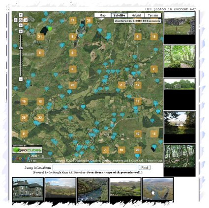
Geograph Images as you Drag - Screenshot
Quite pleased with the latest update to the Geograph Clusters Map. This displays all geograph images on a interactive draggable Google Map. The clustering is powered by Geocubes :) .

However the most exciting part of the update, is the ‘Enable Photo Display’ button. Which once clicked, enables loading a selection of thumbnails as you drag and move the map. Zoom in close enough to see many blue pins for best effect. As you move again, more images will load; the ones shown should always be within the current map view. The data to show images again comes from the Geocubes API, although we load actual thumbnails via our own API.

Google indexes ‘Related Maps’ aka GeoRSS feeds

Saturday, June 27th, 2009

Just stumbled on this today, and not seen it noted anywhere yet, but (recently?) Google has exposed its index of ‘Related Maps’ on Google Maps.

If you open the ‘Show Search Options’ option, there is an entry ‘Related Maps’ – this mainly seems to be GeoRSS feeds its found out in the wild, but does include maps from ‘My Maps’, but strangely not KML files (which are mostly indexed in User-Created Content I guess)

Oh and if you where wondering, yes did find this when checking something out on geograph. (Note the link at the top to view Related Maps)

Still waiting for the day when we get good access to Googles GeoIndex, the AJAX Search API gives very limited (32 results max, and no urls! oh and doesnt include all the options included in the ‘options’ dropdown on Google Maps either), feels so this data could/should be exposed more?

Geolocated websites on the go?

Monday, June 22nd, 2009

Want to quickly access location based websites, while on the go?

Then enter:

m.nearby.org.uk

into your mobile browser.

Very privative, only goes to the nearby location links service, and a few pages on geograph. But between them give access to a fair number of (UK esp) websites.

Disclaimer: Only tested on a Google Android phone so far. Doesn’t seem to pickup GPS position (yet). To be honest surprised not found something like this in the Android Market.

If works out will probably add direct links to other websites, and possibly make it configurable so can choose which sites to show :)

Multi Destination Routing + Altitude Profile

Friday, May 8th, 2009

There is a tool on nearby for taking a multi destination route – and loading it into Google Earth. It was also used to load directions into a “My Map”, but thats basically redundant now, but as the script just converts the directions to a KML file, there are many useful things that can be done with it…

Such as plotting an altitude profile with gpsvisualizer.com***, but to make it even easier, have added a button to the page, that links direct to the form on gpsu with the data prefilled as well as the ‘add altitude’ option enabled.

Enjoy! (Oh and let me know if there are any other interesting destinations would like to load the KML file into!)

Multi Destination Routing Toolkit

*** which Adam recently added the functionalty to add alitude automatically – previsoully a problem as the KML files from Google maps dont include altitude

Directions to My Maps finally!

Thursday, April 23rd, 2009

Google has just added a new feature to Google Maps to save a set of directions into a My Map! This makes obsolete a popular script on ere :)

But they have gone a step further! This screenshot probably explains it best

nice.

(via)

Warning: it seems the ‘Save to My Maps’ overwrites the previous content of a My Map, not append like I would expect :(
Edit: maybe its only temporally, if it happens to you, try disabling and reenabling the map – see comments.