Archive for the ‘Geograph’ Category

Geograph Javascript Playgrounds

Friday, July 1st, 2011


I often have little ideas for new ways to display images from Geograph, but its a pain building prototypes.

It usually involves finding some other part developed prototype or feature, that I can use as a template. Then have start up a code editor, and get connected to a server. Think of a name to call the file. Strip out the bits not needed for the new application. Then have to remind myself the APIs available. Work out how to call the APIs etc, etc, etc.

… well now I’ve began work on a platform to make this easier. Online code editor – quick forking of current projects. Easy wrapped access to relevant APIs, jQuery already loaded.

No more worrying about what to call the file, or making sure I keep backups of previous versions (should want to find a previous one!). This is all handled automatically. Setup to handle browser caching and invalidation on new versions. No worrying about stale code.

It’s primarily for my own use, but thought may as well open it up so others can use it build quick prototypes – or even fully fledged applications (based on Geograph images of course!).

The applications created all run client-side in browser – so utilizes the power of jQuery to create immersive and compelling interfaces.

Probably the best place to start is from a few of the early demos I built with the system:

Public Listed Applications

Please use them as starting points – or simply inspiration to build your own application! (They are not meant as complete applications!)

No special tools required – other than a browser. Firefox with Firebug, or Chrome (press F12!) recommended – to help catch javascript errors.

(note: it only wraps one Geograph API currently – loading all images in a gridsquare – more to be added)
Want a copy of the Geograph Archive? (by snail mail)

Saturday, January 8th, 2011

For the past few months I have been sending out copies of the Geograph Archive (all of it!) on USB hard disks.

If you are interested then let me know, plan to make an order for blank hard disks early next week.

I plan to offer these at £60 a piece – postage to the UK included. Depending on postage worldwide, might be slightly more, quote on request. Which is pretty close to cost.

The drives will be 640G, and include about 490Gb of jpgs. (about 2222222 files) The database and code is included, but that can also be downloaded from online. Probably these.

… With an added twist, will send it completely free (I’ll finance it myself) if you promise to make an application to view the images off the disk (ie works entirely offline). This would have be Open Source so it could be included on future disks, and downloadable for holders of disks already). More details of this on request.

Anybody want to run Geograph Channel Islands?

Monday, October 25th, 2010

A while ago I started putting together a sister project to Geograph Britain and Ireland (and Geograph Germany!); a dedicated project for the Channel Islands.

It ‘freeloaded’ on the back of the Britain and Ireland project and shared the same servers. Alas that is no longer sustainable, and causing issues to the other projects hosted there.

So looking for someone to step up and help with the administrative and hosting. It needs new hosting.

I believe it could fit in the free trial offer from Amazon http://aws.amazon.com/free/ – at least initially (for a year).

Would you be willing to signup? And look after raising funds to pay for it. That could be though ads, donations or sponsorship etc.

It doesnt have to be though Amazon, if can get reasonable hosting elsewhere.

I’ll take care of getting the site running in the new location, and provide lo-fi support to keep it running (the techy stuff). Just can’t justify the administration.

(Contact me via Geograph)

‘Select Search’ Chrome extension – now with added Geograph

Friday, October 15th, 2010

Jérémie, the developer of the ‘Select Search’ Chrome extension has just added support for Geograph.

The extension hovers a small set of icons when select text on a webpage. So that can search for that text on a verity of services.

Extension Page

Will need to enable Geograph in the Extension Options. Of course there are a verity of other sites it can search :)

Deadline extension for Geograph Mashup Challange

Saturday, March 27th, 2010

Due to lack of entries, the date has been extended until 11pm 30th April 2010.

See the original post for more details of the event

So an extra month to work on entries. Also gives me a bit more time to come up with an even better website for the competition!

P.S. The Geograph API has recently been extended to have a JSON API, meaning can be used directly in a Javascript based mashup :)

Geograph Mashup Challenge (new deadline!)

Saturday, February 27th, 2010

We are pleased to announce a developer challenge to build a cool Mashup using Geograph Data/Photos. The closing date for entries is 11pm 31st March 2010, extended until 11pm 30th April 2010.

The first prize is a Space Navigator, with 5 runner up prizes of a Geograph key ring!
Judging will be by a panel of judges and possibly a user vote on a the Challenge showcase web site (TBA).

The rules are simple:

  • Create a web site, mobile, or desktop application (or similar) that uses Geograph data
  • The application must be available for free
  • Of course free to mashup the information with other sources (in fact its encouraged!)
  • Welcome to submit multiple distinct mashups – but each needs to be substantially different.

Other than let your imagination and ingenuity run wild.

Geograph will provide to all entrants:

  • Live API to search/download Photo data – includes hosting for thumbnails only
    • (includes bespoke development at Developers discretion – will try to provide to all that ask within resource constraints)
  • Static Dumps of pretty much the whole Geograph Database (mysql format)
  • Torrent Downloads of a sample of 250,000 images
  • Potentially help with hosting if you don’t have available (please ask!)
  • All confirmed mashups will be showcased/linked on the Challange Website.

This is for Geograph British Isles, but if can incorporate Geograph Germany data too, all the better – what data is available may vary.

For inspiration, offer up my pithy attempt:
Geograph Photos on a OpenSpace Map

Entry Form!

(note this is not sponsored by 3dconnexion – its entirely Geograph run)

Faceted browsing of Geograph images in Flamenco!

Saturday, January 16th, 2010

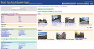
Totally accidently, via a recent Ask-Slashdot post looking for a Search Engine interface, happened across Flamenco search interface framework. It didn’t suit the asker, but its pretty close to great for Geograph, which has lots of categorization. I’ve been looking to build something like this, and have been slowly building the components, scattered around the Geograph website, but havn’t had the time and dedication to pull together. However this interface, does lots and creates a single consistent interface for browsing geograph images, by browsing multiple dimensions of data.

Flamenco screenshot

After a few stumbling blocks getting the python application running on my server (a python noob), set about importing a sample of the Geograph Archive. And frankly the results are nothing short of amazing – esp considering this is the venilla application, next to no customization for Geograph was needed. Try it out by clicking on the screenshot above, or here, wont say too much about how to use it, but its pretty intuitive. Or Direct link to an example results page

Really want to get it going on the whole Geograph archive (1.6 million photos plus) – have a few doubts about running that on my own little server, but definitely going to work towards that.

Geograph Images + Google Maps + Geocubes

Sunday, December 6th, 2009

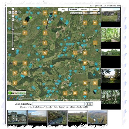
Geograph Images as you Drag - Screenshot
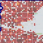
Quite pleased with the latest update to the Geograph Clusters Map. This displays all geograph images on a interactive draggable Google Map. The clustering is powered by Geocubes :) .

However the most exciting part of the update, is the ‘Enable Photo Display’ button. Which once clicked, enables loading a selection of thumbnails as you drag and move the map. Zoom in close enough to see many blue pins for best effect. As you move again, more images will load; the ones shown should always be within the current map view. The data to show images again comes from the Geocubes API, although we load actual thumbnails via our own API.

Pretty Map!

Sunday, September 6th, 2009

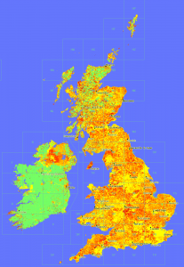
One of the things we been looking recently on Geograph, is guageing how ‘recent’ our coverage actually is. We impose no restriction on when photos where taken – because historical images are useful – not to mention every photo is historic by definition as soon as its taken!
'Age Map'
Anyway the point of this post is in the process decided to try plotting a map showing the ‘age’ of the latest photo in a square – to see that recentness. The result is here:

OMG, quite aside from what it shows, it looks beautiful. (To my untrained eye!)

Click the image for a glorious 1px per km version.

© Copyright 2009 Geograph Project and licensed for reuse under this Creative Commons Licence. (if you want to do anything with it!)

Key: Age less than in years: (0 means no photos yet)
geograph 'depth map' key

There is also a whole series of rendered maps from the project.

Scenicness Map of Great Britain

Friday, August 21st, 2009

This was made a while ago, but never really publised – so time it was given a bit more exposure…

Thanks to the thousands of people rating locations over at ScenicOrNot, and the fact those locations are tied to Geograph images, we can plot the scenicness on a map!

Screenshot of ScenicOrNot data plotted on the Geograph Interactive Mapper

ScenicOrNot based map


The interactive mapper on Geograph now has a ScenicOrNot layer – updated weekly. You can also use the mapper to view the projects coverage so far.
Click the thumbnail to see the map for an area just south of Edinbrough, drag the map for other areas :) . The lighter the colour the more scenic.