Archive for the ‘UK’ Category

Historic OS Maps in Google Earth

Monday, November 8th, 2010

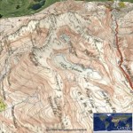
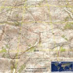
Thanks to the people at getmapping.com, who have taken the Historic 1940s OS Maps available at NPEmap.org.uk, I hearby present:

Historic OS Map layer for Google Earth.

This loads up a layer of Historic New Popular Edition (mainly) maps, onto the 3D Google Earth globe. This is made possible because the original maps are over 50 years old and hence the Crown Copyright has expired.

The getmapping.com WMS service only includes (Most of) England and Wales, no Scotland.

The scans themselves are (c) npemap.org.uk and licenced under this Creative Commons Attribution-NonCommercial Licence 2.5.

(Don’t forget to select the ‘OS Map’ layer, and drag the transparency slider!)

Full UK postcodes in the API!

Friday, April 30th, 2010

Thanks to OS Opendata, the Nearby Converter API now can convert to and from full Unit UK postcodes!

So as not to break applications expecting Sector postcodes in the API, there is a new API endpoint:

http://api1.nearby.org.uk/api/convert.php

API requests against this domain will give the position of the full postcode, and also reverse geocode (return you the nearest) full postcode!

- The Original URL for the API is still available – and will continue to be. I’ve also taken the opportunity to add a version number to the URL. It’s been 4 years since I created this API, and learnt lots in that time, so should be able to create a better version 2 :) When introduce that don’t want to break compatibility.

Of course the ‘Coordinate Convertor‘ is now using CodePoint Open too – the end of having to pay a commercial provider!

(sorry this has taken so long, OS Opendata was introduced at the beginning of the month!, its been a busy month)

Will take the opportunity to duplicate the copyright message:

Contains Royal Mail data © Royal mail copyright and database right 2010.

As it serves as a useful thank you, for making this data available.

UK Onshore geology maps 1:50 000 scale in Google Earth

Sunday, January 3rd, 2010

The BGS recently publised the Geology of Britain website, which makes available a Geological map of Great Britain online in an interactive Map Viewer. They make available a 1:625 000 scale layer for Google Earth, and a the 1:50 000 scale version via WMS only.

Unfortunatly the WMS doesnt play nicely in Google Earth for some reason, so here is a hand tuned Google Earth layer to display the 1:50 000 scale Geological Maps:

http://gokml.net/2sc.kml

Enjoy!

GE: Wales in Hi-Res!

Tuesday, April 1st, 2008

Google Earth has just had its latest update, following tradition the Google LatLong blog releases a cryptic set of clues to the areas effected.

2) jumped out at me considering had to learn that name for school, and being reasonably local. However even more excitedly I notice that pretty much the whole of Wales looks distinctly uniform from far away – suggesting that this update covers pretty much the whole Country :) – the parts in the distant south not included seems to mostly in high res already – being the most populous!

Doesn’t Snowdonia look pretty now? (and the rest of Wales too!)

(Update: follow this post on gearthblog.com for other updates)

Where in Great Britain are people searching?

Saturday, March 1st, 2008

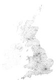
Great Britain usage Coverage map :: NearbyNearby Coordinate Converter >>>
Following on from the Coverage map for Google Earth Layer usage, remembered I been keeping a log from the Coordinate Converter specifically for mapping (but only for GB) , but never actully got round to it, until now that is! Click the image for a full 1px per km version!

British Isles searching Coverage map :: Geograph
Update: Inspired by the above, heres one for the Geograph Search, ok so actully its for the British Isles!
<<<Geograph Searches

Another Whole Myriad :: TG

Sunday, February 10th, 2008

Preview of TG Myriad Mosaic The pace new photos on Geograph is not relenting, so much so we how have another whole Myriad! This time its TG and covers East Anglia and Norwich area, covering 1991 land squares. There is more on the overall progress here, which shows the coverage by Myriad (which by the way is a Geographism for a 100x100km square on the National Grid)

To try to showcase these have been creating some Zoomable viewers to really see the coverage:

Geograph Mosaic Collection

Unfortunatly they require too much manual work to be part of the real site (creating a ‘printable page’ at the appriate scale, stitching all the images, and then running it though zoomifies utility) – but it would be really good to get a Flash programmer to be able to create a viewer like this that runs directly off Geograph tiles!

Playing with (geo-enabled) Full-Text Searches

Thursday, December 20th, 2007

Recently I have been playing a lot with Sphinx full-text search engine, in particular with regard to indexing the Geograph archive. (a bit of background – Geograph has a fairly good homegrown site text search – but its not full text, so many queries will not return that many results – not to mention been based on MySQL ‘like’, so is pretty slow – so a full text search is the next level). And I have to say I am liking it a LOT, in fact I would say I am a fanboy :)

So to that end of created a whole bunch of demos based around the flexible indexing it provides, location based searching is even possible!

At the most basic is simple text based search, one point of note, there is no pagination, simply add more keywords (including negative) or grid references to refine the selection.

Next is a ‘auto-complete’ style image finder, this is designed to find ‘that image’ quickly, in a similar way to the above but shows the results in a autocomplete box immediately!

A refinement of the first is search with location, this allows you limit the search to near a particular Grid References – this is particully cool in that there is Sphinx powered auto-complete for place names for finding GRs. (a real auto-complete not a like the search in the previous one pretending to be one)

This is all building towards the Illustrator demo. Which from a block of text attempts to find relevent images. The idea is that a (geolocated) news article, walking route, place description and such could be automatically have relevent(ish) images shown. (an example demo here)

(a few more ‘toys’ can be found in GeographTools!)…. Try them out and let me know how you get on…

I have learnt a lot about search indexing from this, including how to perform location searches in the index (I know latest versions of sphinx include a lat/long based geosearch – but I think this r-tree method in text has better scalability), and how to create an autocomplete function with sphinx. If anybody is interested in these, they will eventually make it into the geograph codebase, or let me know and I might make a separate post.

Interestingly (huh?), it was actually creating a ‘autocomplete’ textbox for finding trigpoints (which included the forerunner to the sphinx location search in but implemented in mysql), is actually what inspired me to actually go the trouble if figuring out how to install Sphinx on linux, which I have been interested in for a long time! – that is also now sphinx powered for text searches :)

As a side note have now reached the ‘linux sysadmin’ level that I can compile it on Geographes servers, yay! But I do worry for the sanity of others due to this (a little knowledge is a dangerous thing!)

More Maps.Live.com inc KML2RSS

Tuesday, October 16th, 2007

The people at Live.com (Microsoft!) have been making some huge improvements to their map system of late, adding lots of data in both 2D and 3D. maps.live.com has long been good in the UK as it uses imagery from getmapping which is at least 2m resolution, but 25cm in many places. It’s now been backed up by lots of Birds Eye imagry which are static photos taken at an angle, which is great for visualising cities. How these are available in the 3D view (which is currently downloading so havent tried it…) ! Also now supported is visualling KML, GPX and GeoRSS files.
Anyway that was kinda rambley, the point of this post was to highlight small feature I found by accident and not sure it been highlighted on other blogs, namly you can subscribe to a RSS feed for many collections, including a KML or GPX file directly, effectively giving a KML to (Geo)RSS converter!

Example: Recent Geographs KML file as GeoRSS

(looks like we can input any KML/KMZ url in there!)

Building the UK one block at a time!

Monday, August 20th, 2007

Ever played Tetris? Know your geographical areas? If so then its time to play Statetris,

Statetris is an interesting game mixing aspects of the popular game ‘Tetris’ and geography. Instead of positioning the typical Tetris blocks, you position states/countries at their proper location.”

…even better a UK version has just been released!

As the project diversifies to new areas, the creators are facing some interesting challenges to cope with our diverse world. For example the UK is a problem as its so tall, so doesn’t fit on screen as nice as some other areas, not to mention our confusing and changing geography! The Netherlands on the other hand is quite small, so has capitals added to add interest.

What’s your best time?