Archive for January, 2007

Another PhotoSpot

Friday, January 26th, 2007


View at Geograph: SH7840 : Stone on Carnedd Iago
Another in the mini-series of Panoramic Images loaded into Google Earth, using DigitalUrban‘s Panoramic Viewer tutorial.

This one is higher resolution than some of the others and ways in at 525kb,
but the extra resolution is useful to see the distant mountain ranges.

Anyway download it here: Google Earth Version

geotagged More Links for this location

Pen-y-Garn Mountain Panorama for GE

Tuesday, January 23rd, 2007

Following the nice spell of weather thought it an excellent opportunity to capture some images to create another Google Earth PhotoSpot (I still don’t think there is an official name for these).

Pen y Garn Panorama

Download the Google Earth Version (262kb KMZ file).

Used in the making of this: AutoPano*, Paint Shop Pro, DigitalUrban Panorama viewer for GE, (of course) Google Earth, a SpaceNavigator and Winzip 10#.

* (demo version, hence the watermark, first time used but really good, just got to make a usecase to someone to buy it for me ;)

# using Winzip to create the KMZ file seems to manage to squeeze some compression out of the jpg itself :)

Mountain Panorama in Google Earth

Monday, January 15th, 2007

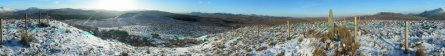
DigitalUrban, has for a while being working on a Panorama Viewer for Google Earth, well to prove that it doesn’t just apply to Urban settings, I have created this panorama of the Top of Snowdon Google Earth File, the highest mountain in Wales (and England).

Really impressive! Just in case you don’t have a SpaceNavigator to really explore, have created a few views, just double click to move around. (idea from Google Earth Blog – except I used folders, so don’t have icons).

To really enjoy the feel of the mountains, I recommend setting your Terrain Exaggeration setting to about 2.0, although having said that the included Snapshot views are designed for when TE is set at 1, as that’s probably the most common.

I should note that I scaled up the model, to make it easier to use, so it does leave a rather large blob on top of the hill! This is also only a rectilinear panorama, rather than spherical, so it will be nice if DigitialUrban can work in support for such images.

geotagged More Links for this location

UK ZIPScribble Map

Saturday, January 6th, 2007

UK ZipScribble MapFollowing inspiration from the US ZIPScribble Map, I have created a UK version. Due to the resolution of the Postcodes in the UK it doesn’t work that well with full postcodes, but using sector postcodes seems to work well, click the thumbnail for a higher resolution version. (yes know some Postcode areas are missing!)

I have split and changed colour between postcode area (the first 1,2 letters), otherwise the sorting is done in alphanumeric order.

(via eagereyes.org blog)