Archive for March, 2008

Bah, Spam!

Monday, March 24th, 2008

(appologies all, this post is simply a rant, and unfortunatly will almost certainly not reach the people its intended for!)

I just noticed that despite only having a very soft launch via this blog, already gokml.net* has attacted submission bots, which seems to have the sole purpose of seeking out submission forms and sending in their masters details, I guess in the hope of getting that little bit of search engine juice.

I guess need to roll out a captcha and/or email confirmation, or maybe even akismet.com?

(as a sidenote, I have a really old form that was intended for people to submit sites for a geoindex, in the nearby location search, I dont think its even linked anymore but it still gets hundreds of submissions daily, I’ve kept it open basically as a honey pot, but unsure what to do with the data, suggestions on a postcard…)

(* a ‘tinyurl’ site for creating network-links for KML content – must also get round to finishing it off…)
Geograph … three years in the making!

Thursday, March 6th, 2008

Geograph is 3

(more)

Towards a standard Geotag Icon?

Sunday, March 2nd, 2008

Geotag DemoJust spotted a proposal for a standard icon to represent geotagged content, the homepage is at geotagicons.com, can’t say a big fan of the icon itself, but the idea is great.

<OT>Was sort of involved in trying to find a standard icon for GeoRSS (in fact they use my icon as the favicon ;) ), but not sure (in hindsight!) if that a good idea, really it just saying this is a geotagged feed, which really shouldn’t mean much different to the end user than the standard feed icon. If their feed reader is geoenabled – great, if not tough, although it can help people specifically looking for geo-content.</OT>

Anyway to try the waters, have enabled it for geotagged content on this blog, see the PhotoSpot category for example :)

(via)

Where in Great Britain are people searching?

Saturday, March 1st, 2008

Great Britain usage Coverage map :: NearbyNearby Coordinate Converter >>>
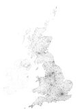
Following on from the Coverage map for Google Earth Layer usage, remembered I been keeping a log from the Coordinate Converter specifically for mapping (but only for GB) , but never actully got round to it, until now that is! Click the image for a full 1px per km version!

British Isles searching Coverage map :: Geograph
Update: Inspired by the above, heres one for the Geograph Search, ok so actully its for the British Isles!
<<<Geograph Searches

Where in the world are people looking? part 2

Saturday, March 1st, 2008

Following part 1 yesterday, have now plotted some maps per individual service.

Flash Earth Layer

Conclusions

  1. Google Earth does request a link for the initial view on startup – that point in the Atlantic.
  2. I guess North American installs have two slightly different default placemarks; has it changed, or maybe Canada gets a different one?
  3. But that doesnt explain the lines from there – people must have their links set to periodically refresh?
  4. Germany likes FlashEarth (or rather people like looking at Germany with FlashEarth link enabled)
  5. Many people leave the links open even when not in use – e.g. the British Isles links show worldwide usage, notably over Russia.
  6. MGRS notably has high usage in two areas.
  7. The Far east likes to know what direction they facing.

Update: In a total forehead slapping momont realised these unprojected whole world images, are exactly what is used in GroundOverlays, so the the pages now include links to view the higher resolution images directly in Google Earth, duh!

Example: View In Google Earth (don’t forget to try adjusting the tranparency slider!) [Update, to fix broken link, sorry!]