Posts Tagged ‘update’

Geograph Images + Google Maps + Geocubes

Sunday, December 6th, 2009

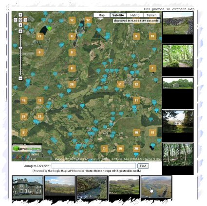
Geograph Images as you Drag - Screenshot
Quite pleased with the latest update to the Geograph Clusters Map. This displays all geograph images on a interactive draggable Google Map. The clustering is powered by Geocubes :) .

However the most exciting part of the update, is the ‘Enable Photo Display’ button. Which once clicked, enables loading a selection of thumbnails as you drag and move the map. Zoom in close enough to see many blue pins for best effect. As you move again, more images will load; the ones shown should always be within the current map view. The data to show images again comes from the Geocubes API, although we load actual thumbnails via our own API.

Geocube Geograph Clusters in Google Earth – part 2

Wednesday, July 15th, 2009

Now ready with the next version of the Geograph Google Earth Clusters layer mentioned yesterday.

Google Earth Layer Geograph Google Earth Clusters

It’s the same download link, if you already have a copy, just right click and select Refresh on the “Geograph Google Earth Clusters” feature.

This has a number of advancements:

  • Filterable – click the main title in the Places panel to open configuration options in the popup balloon. Includes options to filter by keyword or Geograph contributor. (Requires Google Earth version 5)
  • Cubes/Cloud – Geocubes offers two clustering options, can how choose between then on the same popup as above
  • Thumbnails – Now shows a image thumbnail in the placemark balloons.
  • Shows a few coarse clusters when not zoomed on the British Isles
  • Source code available! Download the GPL licenced PHP source code here

But its not all rosey – this version seems to suffer from an annoying bug, when first loads sometimes the layer ‘freezes’ and doesnt automatically update as you move around. If that happens right click on the ‘Clusters’ feature in ‘Places’ and select Refresh, doing that once seems to fix it!

Thanks to Geocubes to the amazing service that powers this – highly recommended if you have larger numbers of features to display!

GE: Wales in Hi-Res!

Tuesday, April 1st, 2008

Google Earth has just had its latest update, following tradition the Google LatLong blog releases a cryptic set of clues to the areas effected.

2) jumped out at me considering had to learn that name for school, and being reasonably local. However even more excitedly I notice that pretty much the whole of Wales looks distinctly uniform from far away – suggesting that this update covers pretty much the whole Country :) – the parts in the distant south not included seems to mostly in high res already – being the most populous!

Doesn’t Snowdonia look pretty now? (and the rest of Wales too!)

(Update: follow this post on gearthblog.com for other updates)