Archive for December, 2009

The Google Earth/Maps Terms of Service

Thursday, December 17th, 2009

Slashgeo has been for the last few months running a poll on users acceptance of the Google Earth/Maps TOS. The poll has now been closed and the results published.

Pretty interesting, aside from the tidbit that most people don’t read the TOS, the number of people actively put off by them is quite high!

I think most of the ‘issue’ comes from the fact that the Universal Terms applies to users, use of both products. In part 11.1. it says “By submitting, posting or displaying the content you give Google a perpetual, irrevocable, worldwide, royalty-free, and non-exclusive licence to reproduce, adapt, modify, translate, publish, publicly perform, publicly display and distribute any Content which you submit, post or display on or through, the Services.

- which to my non-legal mind means Google can take a copy of any data you display in Google Earth or Google Maps – and do what they like with it. It’s irrevocable remember.

On the whole don’t have an issue with this for Google Maps – you pretty much understand you posting public data there. But for Google Earth – which is an application on your own computer – you expect data you display there to NOT be shared with Google and its partners.

Now I am not saying Google will invoke this right and take a copy of your data, its questionable if they would want to, as the data probably lacks context, and there is probably a large amount of it. But they could if the wanted to. And the fact they chosen not to revoke this right, suggests they wanting to leave their options open.

(The Google Maps API has a different TOS, which doesnt encompass the universal terms, so a developer doesnt have to give up a copy of their data unless they choose to)

via Slashgeo
Google powers your GeoDatabase

Sunday, December 13th, 2009

Update: Dec 16th, Offical Blog post is out. And just for interest a TechCrunch post too.

Sometime recently* Google has added ‘geo-filtering’ and attribute filtering to the Google Maps Data API, I haven’t seen any announcement of this or other mention (if it was, it was below my radar), other than a tiny footnote in an Article about doing geo-queries on AppEngine.

Anyway for people not aware of the Google Maps Data API, its basically a programmatic access method to the ‘My Maps’ feature of Google Maps. So with the API you can use Google Maps as your Geo-Database. (Subject I believe to a limit of 10,000 features per ‘Map’, but can have many maps)

However it wasn’t all that useful, as all you could do was inject your data, or read it all back. But now that searching and filtering is possible, it makes the API a viable method store your data for a Google Maps API or similar mashup. As soon as you get beyond a trival number of markers, you need to store your data in a database, and being able to only fetch the features in the current viewport is a good way of only working with a small subset at once.

Curouslly, there doesn’t seem to be a ‘limit’; so a big bounding box, could potentially still access many features. But hopefully that will be rectified soon.
Update2: Seems there is a max-results : handy!

Google Earth – sans GoogleUpdate!

Tuesday, December 8th, 2009

I not sure how new this is, but something I only just noticed…

Google now (officially) offers to install Google Earth without the dreaded GoogleUpdate!

It’s only offered when clicking the small ‘advanced setup‘ link on the main Download Earth page. But I think that is ok, using the updater is probably a sensible default, most people will get along just fine with auto-updating. What I have long bemoaned is there was no official way to opt out for people needing or wishing to.

Here’s that link again just in case:

Advanced Google Setup

Thank You Google!

Geograph Images + Google Maps + Geocubes

Sunday, December 6th, 2009

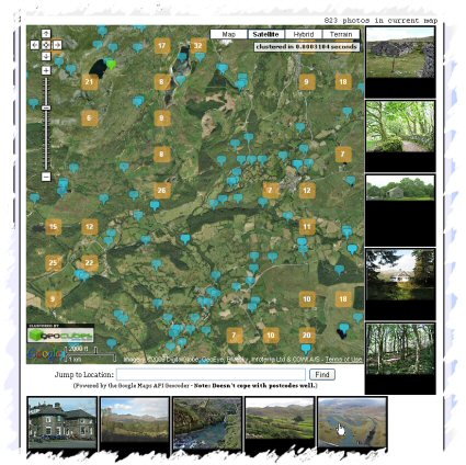
Geograph Images as you Drag - Screenshot
Quite pleased with the latest update to the Geograph Clusters Map. This displays all geograph images on a interactive draggable Google Map. The clustering is powered by Geocubes :) .

However the most exciting part of the update, is the ‘Enable Photo Display’ button. Which once clicked, enables loading a selection of thumbnails as you drag and move the map. Zoom in close enough to see many blue pins for best effect. As you move again, more images will load; the ones shown should always be within the current map view. The data to show images again comes from the Geocubes API, although we load actual thumbnails via our own API.