Posts Tagged ‘Geograph’

Geograph Channel Islands is back!

Thursday, February 10th, 2011

Sorry all for the extended outage on Geograph Channel Islands site. It used to share servers with Britain and Ireland, but that caused a number of stability issues. (caused mainly by a bug in APC I believe!)

Anyway, we are now hosted on CatN‘s vCluster platform.
CatN is by the same people who provide colocation hosting for Geograph, so the move isn’t actually far (both Geographically, and Virtually ;) .

Separating Channel Islands site into a more standalone project, should hopefully also make the site easier to manage – and give more flexibility to grow.

(Next project is moving Geograph Portals to vCluster too, but I’m going to have do some more work on the code first)
Want a copy of the Geograph Archive? (by snail mail)

Saturday, January 8th, 2011

For the past few months I have been sending out copies of the Geograph Archive (all of it!) on USB hard disks.

If you are interested then let me know, plan to make an order for blank hard disks early next week.

I plan to offer these at £60 a piece – postage to the UK included. Depending on postage worldwide, might be slightly more, quote on request. Which is pretty close to cost.

The drives will be 640G, and include about 490Gb of jpgs. (about 2222222 files) The database and code is included, but that can also be downloaded from online. Probably these.

… With an added twist, will send it completely free (I’ll finance it myself) if you promise to make an application to view the images off the disk (ie works entirely offline). This would have be Open Source so it could be included on future disks, and downloadable for holders of disks already). More details of this on request.

Anybody want to run Geograph Channel Islands?

Monday, October 25th, 2010

A while ago I started putting together a sister project to Geograph Britain and Ireland (and Geograph Germany!); a dedicated project for the Channel Islands.

It ‘freeloaded’ on the back of the Britain and Ireland project and shared the same servers. Alas that is no longer sustainable, and causing issues to the other projects hosted there.

So looking for someone to step up and help with the administrative and hosting. It needs new hosting.

I believe it could fit in the free trial offer from Amazon http://aws.amazon.com/free/ – at least initially (for a year).

Would you be willing to signup? And look after raising funds to pay for it. That could be though ads, donations or sponsorship etc.

It doesnt have to be though Amazon, if can get reasonable hosting elsewhere.

I’ll take care of getting the site running in the new location, and provide lo-fi support to keep it running (the techy stuff). Just can’t justify the administration.

(Contact me via Geograph)

For Developers – download the (whole) Geograph Database

Monday, October 12th, 2009

Geograph is steadily amassing a huge amount of data, and due to the fact that we require images to be Creative Commons Licensed, we release the whole Archive under such a licence, for just about any use people can think of.

Now we have always been more that happy to produce and give out bulk dumps on demand to anyone who asks, we provide a live API, and even bittorrent based downloads of the images themselves (although admittedly they are a bit behind schedule!).

So in an effort to make it even quicker to get going on new ideas, we have began to put together a self service bulk data download site. So from the following page you can access MySQL dumps of the whole image database, as well as supplementary data such as extracted terms and words – ideal for making search engines and mashups, of course includes the full geographical locational data of the images.

data.geograph.org.uk/dumps

The only caveat is the data doesn’t include enough info to build a link to the image file on our servers. We are doing this because we don’t want to make it easy for people to spider large quantities of images, however contact us and we will see what we can do… we are normally happy to allow hotlinking of thumbnail images as long as we know about it.

This is only the beginning so let us know about your suggestions!

Pretty Map!

Sunday, September 6th, 2009

One of the things we been looking recently on Geograph, is guageing how ‘recent’ our coverage actually is. We impose no restriction on when photos where taken – because historical images are useful – not to mention every photo is historic by definition as soon as its taken!
'Age Map'
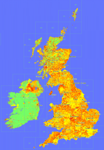
Anyway the point of this post is in the process decided to try plotting a map showing the ‘age’ of the latest photo in a square – to see that recentness. The result is here:

OMG, quite aside from what it shows, it looks beautiful. (To my untrained eye!)

Click the image for a glorious 1px per km version.

© Copyright 2009 Geograph Project and licensed for reuse under this Creative Commons Licence. (if you want to do anything with it!)

Key: Age less than in years: (0 means no photos yet)
geograph 'depth map' key

There is also a whole series of rendered maps from the project.

Geocube Geograph Clusters in Google Earth – part 2

Wednesday, July 15th, 2009

Now ready with the next version of the Geograph Google Earth Clusters layer mentioned yesterday.

Google Earth Layer Geograph Google Earth Clusters

It’s the same download link, if you already have a copy, just right click and select Refresh on the “Geograph Google Earth Clusters” feature.

This has a number of advancements:

  • Filterable – click the main title in the Places panel to open configuration options in the popup balloon. Includes options to filter by keyword or Geograph contributor. (Requires Google Earth version 5)
  • Cubes/Cloud – Geocubes offers two clustering options, can how choose between then on the same popup as above
  • Thumbnails – Now shows a image thumbnail in the placemark balloons.
  • Shows a few coarse clusters when not zoomed on the British Isles
  • Source code available! Download the GPL licenced PHP source code here

But its not all rosey – this version seems to suffer from an annoying bug, when first loads sometimes the layer ‘freezes’ and doesnt automatically update as you move around. If that happens right click on the ‘Clusters’ feature in ‘Places’ and select Refresh, doing that once seems to fix it!

Thanks to Geocubes to the amazing service that powers this – highly recommended if you have larger numbers of features to display!

Geograph Germany (quietly) launches!

Wednesday, February 18th, 2009

It’s very nearly happened a number of times before, but its now offical we have the first Geograph website for another country! 

This is the though the hard work of Hansjörg Lipp, fighting though the various land mines we have left in the open source code that powers geograph. As developers we (well mainly me – I am a lazy programmer!) have taken a number of shortcuts it just getting it to work the quickest way for us in the British Isles, so while the intention its should be easy to start another country it was never as easy as it should be.

You can see the site here:

http://geo.hlipp.de/

which will hopefully be translated fully to Germany. There is also a English language version here:

http://geo-en.hlipp.de/

which still connects to the same database :)

You can read about the experience of working with the code here :)

Its still early days for the project (it only covers a few provinces of southern Germany so far), but its really exciting to see a new site based on the Geograph concept (and code!), we wish Hansjörg Lipp and his team every success. (I wont embarrass myself trying to put any German in here!)

How Geograph survived the BoingBoing effect…

Sunday, October 19th, 2008

… so its 1am on an idle Wednesday (and you really thinking of heading to bed) when someone on the forum mentions the 1 millionth photo will be going soon, so you think Na, its too early, but out of interest you go and check anyway… And you find in fact its right there about to go in a matter of seconds (going on moderation time) … and then you exclaim,

oh carp, oh carp, oh carp (or words to that effect)

… why do I say that? Well the thing is I know that Geograph runs pretty close to the limit* hosting wise, and this milestone, could, should and probably will, make a big splash, suddenly have mental images of Geograph exploding in a fireball, … not good!

(note, the rest of this post uses a few technical terms, and is rather long, turn away now if that scares you…)

(more…)

Over one MILLION Geograph Images!

Wednesday, October 15th, 2008

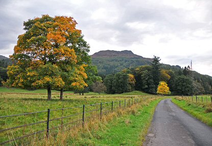
Geograph has just reached a pretty significant milestone, we how have over 1,000,000 images live on the site, all creative commons licenced for reuse goodness. The image that took us over the tipping point is reproduced below, but it is but one image of a million, so thanks to all the amazing contributors that has made this milestone possible. 


by Dr Richard Murray

Minor road near Aberuchil

 © Copyright Dr Richard Murray and licensed for reuse under this Creative Commons Licence.

Update, In the Press: Offical (login required) (RSS), Paul’s Blog, Boing Boing, Reddit, and Digg

(more…)

Geograph: Watching the Fire build

Wednesday, August 13th, 2008

Coverage Animation As we near the Million mark on photos uploaded to Geograph British Isles, the coverage is really building up; and the project has definitly matured from just capturing a photo of every square (but that is still continuing!), to capturing each square in ‘depth’. We display the current coverage on the site as a depth map, but here we present some animations to watch the progress.

There are a number of interesting artefacts in this, if you are quick you can follow people as the hike long distance paths, but you can also see the people making concerted efforts to knock of hectads.

Of course the raw frames are available under Creative Commons, and a bonus prize to who can make an good mashup of these. The animations include both weekly frames, and monthly versions (labelled quick)

(the fire reference)

Depth Key