Archive for the ‘Geograph’ Category

Geocube Geograph Clusters in Google Earth

Wednesday, July 15th, 2009

It’s about time did some Google Earth hacking, so thanks to the people at Geocubes, have made a new interactive layer for Google Earth.

Geograph Google Earth Clusters

This works in a similar way to the Geograph SuperLayer, by showing coverage overview, and then zooming in to reveal more detail. The Geocubes layer has the advantage that the clusters work into a closer zoom, and updates to the geograph database make it into the layer within hours. The SuperLayer is slower updating (weeks), but navigating should be much quicker being as its based on KML regions.

You can view also a Google Maps based version of the layer, using the Geocubes API directly.

This is only version 0.1 – there is more to be done – including being able to filter the results based on words and contributor, but this is exciting enough on its own. Once done a bit of work on tidying up the code plan to release it so others can use the geocubes service to create their own layer like this :) Watch this space!

Where in British Isles are people viewing photos?

Friday, April 24th, 2009

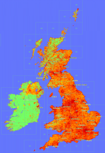
view-depth1-9
In a similar vain to the maps produced here, now that Geograph British Isles has a view counter for each and every photo, we can plot maps of viewing. :)

This map is obviouslly heavily influenced by where photos have actully been submitted; s for comparison here is a depth map of photo submissions.

Don’t know what it means, or if actully useful, but sure is pretty!


(click the thumbnail to see 1px per km scale version)

is it ScenicOrNot?

Saturday, April 4th, 2009

ScenicOrNot

ScenicOrNot is a new mashup from the good people at mySociety – with the simple aim of finding the scenic spots across Great Britain; I’ve no idea what the super secret purpose of this site is, but they have promised to release the data, so it could be used in lots of exciting ways… 


Oh and of course the photos are sourced from Geograph British Isles.

Go rate a grid square now! Also at http://digg.com/u18iG

Geograph Germany (quietly) launches!

Wednesday, February 18th, 2009

It’s very nearly happened a number of times before, but its now offical we have the first Geograph website for another country! 

This is the though the hard work of Hansjörg Lipp, fighting though the various land mines we have left in the open source code that powers geograph. As developers we (well mainly me – I am a lazy programmer!) have taken a number of shortcuts it just getting it to work the quickest way for us in the British Isles, so while the intention its should be easy to start another country it was never as easy as it should be.

You can see the site here:

http://geo.hlipp.de/

which will hopefully be translated fully to Germany. There is also a English language version here:

http://geo-en.hlipp.de/

which still connects to the same database :)

You can read about the experience of working with the code here :)

Its still early days for the project (it only covers a few provinces of southern Germany so far), but its really exciting to see a new site based on the Geograph concept (and code!), we wish Hansjörg Lipp and his team every success. (I wont embarrass myself trying to put any German in here!)

Ask the audience… how to promote long term seeding?

Friday, February 6th, 2009

Geograph offers bulk Torrent downloads, of images. All good (we hope!), but a major reason for doing this is to utalise the power of p2p and share the bandwidth bill. We have bordering on 150Gb of image data to share, but everybody downloading that data from our servers is, well a LOT, not to mention slow, and using bandwidth that could otherwise be serving regular visitors. (the alternative is to serve it from home – but using the upstream connection for that size is also really slow…) 

But to do this is needs others to help with the seeding – in the long term. For a while now 90% of downloading is coming from a seed I have on a server, ie people are peering while downloading, but as soon as the download is completed… its ‘thanks for the fish’ and they are gone.

(we could seed from our homes too, but with the server offering a big enough pipe theres no need – yes aware of the irony in that statement – but we already paying for the server) 

So what can be done to help encourage others to stick around and help?  One consideration is the torrents include the raw files – rather than a tar or similar, making it easy to keep the torrent software pointed at the folder that actullly use the images – without duplication. 

What if the files where made smaller?  (but would mean many more torrents – and the assumption is people are pretty much wanting most images, so picking and choosing isnt really going to happen) 

One critism is the metadata in the files, is hard to keep uptodate – the metatdata is updated on the site from time to time. But for the most part that can be considered a different issue, we can offer bulk downloads of data – on a bespoke basis. (and have an API

I’ve looked around the interweb, and this does crop up occasionally. But our case is somewhat unique; its a specialist market (so really at most 1 or 2 downloaders at once), the files on the large size, and we’er in this for the long term (decades ideally!).

Run (& Develop) Geograph locally!

Saturday, December 13th, 2008

I’ve prepared a VMware virtual machine, that contains a ready to run instance of Geograph (British Isles). This was primarlly for my own purposes as my current working copy runs on windoz, so didn’t replicate fully the real enviroment. Now I can still run my IDE on windows, but have the code running in a almost totally faithful copy. 

The compressed image is available from:

Geograph Torrents Downloads (346.62 MB)

Requirements to run the image:

  • WMware workstation or WMare player
  • a 7z uncompression tool (apparently the best compression method for VM images)
  • At least 3GB diskspace (the image’s disk uncompressed needs 2GB – but could expand to 10GB)
  • web-browser (to actully view something) 
  • A smattering of linux know-how (to actully login and view the files – also to try changing things) 
  • To do anything useful, experience with PHP, mySQL and website development in general, is a big bonus

The image’s application database is empty – it contains no photos or other data from Geograph British Isles, other than the bare minimum to get running (but contains the non-copyrighted BI geodata for map plotting etc). If you want a developers dump to try loading some real data please get in touch with the team. 

Hopefully this should be a real quickstart way to get a local working copy running – ready setup with required software, cronjobs etc – ideal for:

  • Just finding out more about how the site works :)
  • Doing real development work – with the aim to contribute back (its ready setup for easy SVN commits) 
  • To customise the code for a new country! (we have plans to make this even easier)

(NB. only torrent download currently available – others probably available on request)

Enjoy!

How Geograph survived the BoingBoing effect…

Sunday, October 19th, 2008

… so its 1am on an idle Wednesday (and you really thinking of heading to bed) when someone on the forum mentions the 1 millionth photo will be going soon, so you think Na, its too early, but out of interest you go and check anyway… And you find in fact its right there about to go in a matter of seconds (going on moderation time) … and then you exclaim,

oh carp, oh carp, oh carp (or words to that effect)

… why do I say that? Well the thing is I know that Geograph runs pretty close to the limit* hosting wise, and this milestone, could, should and probably will, make a big splash, suddenly have mental images of Geograph exploding in a fireball, … not good!

(note, the rest of this post uses a few technical terms, and is rather long, turn away now if that scares you…)

(more…)

Over one MILLION Geograph Images!

Wednesday, October 15th, 2008

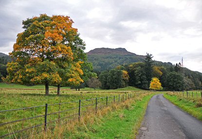
Geograph has just reached a pretty significant milestone, we how have over 1,000,000 images live on the site, all creative commons licenced for reuse goodness. The image that took us over the tipping point is reproduced below, but it is but one image of a million, so thanks to all the amazing contributors that has made this milestone possible. 


by Dr Richard Murray

Minor road near Aberuchil

 © Copyright Dr Richard Murray and licensed for reuse under this Creative Commons Licence.

Update, In the Press: Offical (login required) (RSS), Paul’s Blog, Boing Boing, Reddit, and Digg

(more…)

Geograph: Watching the Fire build

Wednesday, August 13th, 2008

Coverage Animation As we near the Million mark on photos uploaded to Geograph British Isles, the coverage is really building up; and the project has definitly matured from just capturing a photo of every square (but that is still continuing!), to capturing each square in ‘depth’. We display the current coverage on the site as a depth map, but here we present some animations to watch the progress.

There are a number of interesting artefacts in this, if you are quick you can follow people as the hike long distance paths, but you can also see the people making concerted efforts to knock of hectads.

Of course the raw frames are available under Creative Commons, and a bonus prize to who can make an good mashup of these. The animations include both weekly frames, and monthly versions (labelled quick)

(the fire reference)

Depth Key

Geograph by Bittorrent!

Tuesday, July 1st, 2008

Lordelph has just setup a new system to distribute the Geograph archive by bittorrent! For this to work really well we need as many people to help seed as possible, so if you are able please do!

I have a number of servers sitting around that could help with this, so I am particularly keen to have a client that can be setup on linux boxes easy, Lordelph pointed me towards rtorrent which so far seems to be working well. I don’t have time to document it fully now, but below is a quick start guide to what I did to get it going (on Fedora, other flavours very similar), with minimal fuss. The next step will be to have a script to automatically discover new torrents.

#install rtorrent (using yum as fedora)
yum install rtorrent

#create user and folder
adduser geotorr
mkdir /var/geotorr
chown geotorr:geotorr /var/geotorr

#setup initial enviroment
su geotorr
mkdir /var/geotorr/session
mkdir /var/geotorr/watch
cd /var/geotorr/watch/
wget http://torrents.geograph.org.uk/torrents/geograph_vol001_image_0_to_49999.torrent

#create config file (setting up to use created folder, and to setup watch and session folders)
# paste in the example from http://libtorrent.rakshasa.no/browser/trunk/rtorrent/doc/rtorrent.rc?rev=latest and edit
# or see my version available at http://barry.pastebin.com/f6f861f59
nano ~/.rtorrent.rc

#but see also (haven't read it myself!)
# http://kmandla.wordpress.com/2007/05/02/howto-use-rtorrent-like-a-pro/

# then to add new torrents in future just drop the .torrents files in the watch folder
# - a little script that follows that RSS feed would do nicely here!

more… on the geograph forum.

Edited Tues PM for spelling and grammar – the previous post wasn’t proof-read!