Posts Tagged ‘Google Earth’

Google Earth should make the sea floor rendering optional?

Monday, July 5th, 2010

Way back when, I wrote a rather scathing review of the then new “sea floor” imagery. This takes the form of a rendering supposed to represent the ’3Dness’ of the sea floor, persumably to improve the feel when exploring under the water surface.

Indeed it would look off, to ‘fly’ under the sea, and then see surface imagry projected onto the both bottom.

Alas that comes at a high price, namely that this imagery is ‘allways on’, so you see it even when not exploring the oceans. This has the effect of obscuring valuable imagry in shallow water areas (where real features are visible in the imagry), with the low resolution rendering.

But also where the ‘switch’ happens between the aerial imagry and the subsurface rendering is somewhat arbitary, and results in a ugly join when viewed at close range. At a distance the colour differential between the shallow sea and the greenish land is greatly reduced (to my colour blind eyes at least), leaving the land boundaries very hard to discern.

So, if you agree, please see:

Petition: Google Earth should make the sea floor rendering optional

Extra note: Of course anothe benefit of bing a ‘optional’ layer, Google Earth could even be made to automatically turn the layer when fly below the water surface, but above the surface its off.

Sea Floor: [X] Off, [ ] On, [ ] Show when under the water serface

GE5. The Ocean – Time Machine – Tour Recorder – oh and Mars

Monday, February 2nd, 2009

Seems reports that Google Ocean where pretty accurate, Google have just released Google Earth v5, which besides the extra Sea floor data we saw last week, it actully makes the sea transparent so you can fly underwater… (not to mention a new ‘Ocean’ set of layers)

But thats not all, there are a wealth of other features…

  • Historic data, – you can now turn back time, and view older imagary. The data base is pretty comprensive – and quick! – but I guess (hope!) that more data will be added too…. 
  • Touring – From a couple of quick plays, GE5 has a new tour recording mode. Very easy to use, and seems to even capture changes to places (found by accident, correction: its “places” only, doesnt capture “layers” :( ), and even changes to the time slider
  • Planetry Bodies – The old ‘sky’ button is now a dropdown – with the addition of Mars. Its been possible to view mars imagry for a while, but its now in glorious 3D! (and gets its own set of layers) 
  • Update: Richer HTML balloons – now balloons are rendered by a webkit browser, with Javascript and iFrames support! (more in a later post)

other minor changes…

  • More sun – the sun works for not just the past 24 hours now it seems. 
  • New Timeslider – To ammonodate the new imargy and sun, the slider has been redesigned and moved. It even glows showing historic imagery, but its little difficult to get to grip – (update: not too bad with some practice! – perhaps it was just slow before…)
  • Overview Map moved – its now behind the Google Logo! Guess that saves space….
  • Update: Support for non rectangular groundoverlys. (more)
  • KML Extensions - When copying KML out of the client it starts with:

<kml xmlns=”http://www.opengis.net/kml/2.2″ xmlns:gx=”http://www.google.com/kml/ext/2.2″ xmlns:kml=”http://www.opengis.net/kml/2.2″ xmlns:atom=”http://www.w3.org/2005/Atom”>

so it looks like extra stuff there – the new tours seems to be the main thing added in the gx namespace. Find out more about the Google Extensions Namespace: (more in a later post). Looks like this is going to be the way Google specific updates to KML is going to be handled now KML is controlled by OGC. 

Update(s): 

re KML namespace: making a few play tours and copying out the KML, the ‘touring language’ seems very comprehensive, recorsds small changes to view as a bunch of <Camera>, and pauses. Also only just noticed a ‘mic’ button, gonna have to dig out a microphone to try it… (I guess it can record a soundtrack for the tour)

Oh of course, there are plenty of further readings… GearthBlog 1 2, Google LatLong, Offical Google Blog. Offical site 1, 2. Oh more about the gx extension namespace: Brian Flood

Looking at the screenshots on gearthblog, my sea doesnt look like that its all static , I guess I need a better graphics card….
Stereoscopic (3D) Earth

Thursday, June 19th, 2008

Alerted by ogleearth to an interesting mashup with the new Google Earth Plugin, that promises Stereo viewing of earth I couldnt wait to get home to try on my windows machine….

However try as a I might I could not cross my eyes enough to see it in all its glory. So I copied* the code and made the size of of the globes configurable (well I first tried just changing the hardcoded value), and the result is:

stereo-earth.php?s=200

I found I can get it to work on 200pixels, any bigger and just couldnt manage it, but try it yourself (change the numbers in the url).

Another tip: press F11 to remove distracting screen clutter.

* The original Google demo is under the Apache licence, so assume the Stereoscopic version is too, so this one is also, although the PHP is rather boring.

Google Earth in the Browser

Wednesday, May 28th, 2008

Google has just announced a new Google Earth API – which allows embedding and fully functional Google Earth in just about any webpage. Even is easily intergratable with Google Maps API mashups – with very little extra code. (takes a number of seconds for that news to sink in!)

Be sure to checkout the samples, (particularly the milktruck demo!), I’ve also started trying it out with a few demos of my own

…Windows only btw…

Expect A LOT MORE from this very flexible looking API – the JS interface can quickly interact with objects (API is based around KML) and gets pretty good control of interface options.

Update: mentioned on gearthblog.com which is a good introduction about what this is and what its not!

Update2: and to show it can basically be added to a ‘real world’ Gmaps mashup, in a few lines of code, see here

GE4.3 Compass Star

Saturday, April 26th, 2008

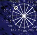
Compass While playing with the new navigation in Google Earth 4.3, noticed its not always easy to get your bearings (bad pun), also been wanting to play in PSP today, so set to do something about both. The result? A ScreenOverlay showing a compass star on the navigation control.

Google Earth Overlay . GE Compass Star (without numbers)

Note: I do also have a network link that shows the more exact bearing as a placemark label.

(part inspired by)

Updated to add: This has inspired a similar compass that rotates, nice work Gerardo64!

GE: Wales in Hi-Res!

Tuesday, April 1st, 2008

Google Earth has just had its latest update, following tradition the Google LatLong blog releases a cryptic set of clues to the areas effected.

2) jumped out at me considering had to learn that name for school, and being reasonably local. However even more excitedly I notice that pretty much the whole of Wales looks distinctly uniform from far away – suggesting that this update covers pretty much the whole Country :) – the parts in the distant south not included seems to mostly in high res already – being the most populous!

Doesn’t Snowdonia look pretty now? (and the rest of Wales too!)

(Update: follow this post on gearthblog.com for other updates)

Where in the world are people looking? part 2

Saturday, March 1st, 2008

Following part 1 yesterday, have now plotted some maps per individual service.

Flash Earth Layer

Conclusions

  1. Google Earth does request a link for the initial view on startup – that point in the Atlantic.
  2. I guess North American installs have two slightly different default placemarks; has it changed, or maybe Canada gets a different one?
  3. But that doesnt explain the lines from there – people must have their links set to periodically refresh?
  4. Germany likes FlashEarth (or rather people like looking at Germany with FlashEarth link enabled)
  5. Many people leave the links open even when not in use – e.g. the British Isles links show worldwide usage, notably over Russia.
  6. MGRS notably has high usage in two areas.
  7. The Far east likes to know what direction they facing.

Update: In a total forehead slapping momont realised these unprojected whole world images, are exactly what is used in GroundOverlays, so the the pages now include links to view the higher resolution images directly in Google Earth, duh!

Example: View In Google Earth (don’t forget to try adjusting the tranparency slider!) [Update, to fix broken link, sorry!]

(static) Google Maps in Google Earth…

Thursday, February 21st, 2008

Now that Google have just announced a brand spanking new NON JS Maps API, to be able to display maps with a simple img tag, similar to the Chart API. Well I thought it would be fun to re-purpose the
FlashEarth code to create a network link to display Google Maps in a popup balloon on Google Earth. Not totally sure the utility, but sure is fun (until the novelty wears off!)

Open in Google Earth

Hopefully needless to say the map inside the balloon is static and non draggable.

Update to clarify: You get to draw 1,000 maps daily, which is probably plenty, but go over that and the maps will stop working for you.

Update: as alluded to in the official post, you can use the static API to load a quick map, while the rest of the page loads, then at the last minute change it into a dynamic map. A series of demos showing various ways of lazy loading!

Publish your KML via Google

Thursday, January 31st, 2008

Lately I have have been playing a lot with displaying KML files on various properties of Googles, and I thought it was about time I bookmarked the useful pages for my own reference – Firefox has them in the recent list now, but in 2 months time? Anyway in the end thought it would only take bit longer to collate them in a webpage, and make them dynamic links, so without further ado:

Useful links for publishing a KML via Google