For Developers – download the (whole) Geograph Database

October 12th, 2009

Geograph is steadily amassing a huge amount of data, and due to the fact that we require images to be Creative Commons Licensed, we release the whole Archive under such a licence, for just about any use people can think of.

Now we have always been more that happy to produce and give out bulk dumps on demand to anyone who asks, we provide a live API, and even bittorrent based downloads of the images themselves (although admittedly they are a bit behind schedule!).

So in an effort to make it even quicker to get going on new ideas, we have began to put together a self service bulk data download site. So from the following page you can access MySQL dumps of the whole image database, as well as supplementary data such as extracted terms and words – ideal for making search engines and mashups, of course includes the full geographical locational data of the images.

data.geograph.org.uk/dumps

The only caveat is the data doesn’t include enough info to build a link to the image file on our servers. We are doing this because we don’t want to make it easy for people to spider large quantities of images, however contact us and we will see what we can do… we are normally happy to allow hotlinking of thumbnail images as long as we know about it.

This is only the beginning so let us know about your suggestions!
Pretty Map!

September 6th, 2009

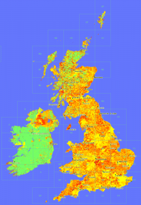
One of the things we been looking recently on Geograph, is guageing how ‘recent’ our coverage actually is. We impose no restriction on when photos where taken – because historical images are useful – not to mention every photo is historic by definition as soon as its taken!
'Age Map'
Anyway the point of this post is in the process decided to try plotting a map showing the ‘age’ of the latest photo in a square – to see that recentness. The result is here:

OMG, quite aside from what it shows, it looks beautiful. (To my untrained eye!)

Click the image for a glorious 1px per km version.

© Copyright 2009 Geograph Project and licensed for reuse under this Creative Commons Licence. (if you want to do anything with it!)

Key: Age less than in years: (0 means no photos yet)
geograph 'depth map' key

There is also a whole series of rendered maps from the project.

Scenicness Map of Great Britain

August 21st, 2009

This was made a while ago, but never really publised – so time it was given a bit more exposure…

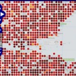
Thanks to the thousands of people rating locations over at ScenicOrNot, and the fact those locations are tied to Geograph images, we can plot the scenicness on a map!

Screenshot of ScenicOrNot data plotted on the Geograph Interactive Mapper

ScenicOrNot based map


The interactive mapper on Geograph now has a ScenicOrNot layer – updated weekly. You can also use the mapper to view the projects coverage so far.
Click the thumbnail to see the map for an area just south of Edinbrough, drag the map for other areas :) . The lighter the colour the more scenic.

Geocube Geograph Clusters in Google Earth – part 2

July 15th, 2009

Now ready with the next version of the Geograph Google Earth Clusters layer mentioned yesterday.

Google Earth Layer Geograph Google Earth Clusters

It’s the same download link, if you already have a copy, just right click and select Refresh on the “Geograph Google Earth Clusters” feature.

This has a number of advancements:

  • Filterable – click the main title in the Places panel to open configuration options in the popup balloon. Includes options to filter by keyword or Geograph contributor. (Requires Google Earth version 5)
  • Cubes/Cloud – Geocubes offers two clustering options, can how choose between then on the same popup as above
  • Thumbnails – Now shows a image thumbnail in the placemark balloons.
  • Shows a few coarse clusters when not zoomed on the British Isles
  • Source code available! Download the GPL licenced PHP source code here

But its not all rosey – this version seems to suffer from an annoying bug, when first loads sometimes the layer ‘freezes’ and doesnt automatically update as you move around. If that happens right click on the ‘Clusters’ feature in ‘Places’ and select Refresh, doing that once seems to fix it!

Thanks to Geocubes to the amazing service that powers this – highly recommended if you have larger numbers of features to display!

Geocube Geograph Clusters in Google Earth

July 15th, 2009

It’s about time did some Google Earth hacking, so thanks to the people at Geocubes, have made a new interactive layer for Google Earth.

Geograph Google Earth Clusters

This works in a similar way to the Geograph SuperLayer, by showing coverage overview, and then zooming in to reveal more detail. The Geocubes layer has the advantage that the clusters work into a closer zoom, and updates to the geograph database make it into the layer within hours. The SuperLayer is slower updating (weeks), but navigating should be much quicker being as its based on KML regions.

You can view also a Google Maps based version of the layer, using the Geocubes API directly.

This is only version 0.1 – there is more to be done – including being able to filter the results based on words and contributor, but this is exciting enough on its own. Once done a bit of work on tidying up the code plan to release it so others can use the geocubes service to create their own layer like this :) Watch this space!

Re: Three key things to know about moving MySQL into the cloud.

July 14th, 2009

As the comments on the original post dont seem to work (wp-comments.php returns a empty page) – will try replying via a blog post and see if the trackback is picked up.

Re 1. Isn’t that what “Elastic IP“s do? – “Virtual IP”s that you can map to which ever instance you like.

Awesome

July 7th, 2009

Just found this GreaseMonkey script:

Gmail – Hide Selected Label

Which removes the REALLY annoying redundant tag from when viewing all results from a tag. This has been enough to keep me on the ‘Older Version’ of Google Mail.

Works great in Firefox, now to figure out how to get it working in Chrome (uses as yet unsupported features).

Google indexes ‘Related Maps’ aka GeoRSS feeds

June 27th, 2009

Just stumbled on this today, and not seen it noted anywhere yet, but (recently?) Google has exposed its index of ‘Related Maps’ on Google Maps.

If you open the ‘Show Search Options’ option, there is an entry ‘Related Maps’ – this mainly seems to be GeoRSS feeds its found out in the wild, but does include maps from ‘My Maps’, but strangely not KML files (which are mostly indexed in User-Created Content I guess)

Oh and if you where wondering, yes did find this when checking something out on geograph. (Note the link at the top to view Related Maps)

Still waiting for the day when we get good access to Googles GeoIndex, the AJAX Search API gives very limited (32 results max, and no urls! oh and doesnt include all the options included in the ‘options’ dropdown on Google Maps either), feels so this data could/should be exposed more?

Geolocated websites on the go?

June 22nd, 2009

Want to quickly access location based websites, while on the go?

Then enter:

m.nearby.org.uk

into your mobile browser.

Very privative, only goes to the nearby location links service, and a few pages on geograph. But between them give access to a fair number of (UK esp) websites.

Disclaimer: Only tested on a Google Android phone so far. Doesn’t seem to pickup GPS position (yet). To be honest surprised not found something like this in the Android Market.

If works out will probably add direct links to other websites, and possibly make it configurable so can choose which sites to show :)

ITM <-> WGS84 (<-> Irish Grid <-> British National Grid) PHP code

May 13th, 2009

With Ireland soon to be moving to ITM (Irish Transverse Mercator) coordinates, over IG (Irish Grid) that has been used since about 1965 in Ireland, many websites – including Geograph.ie and nearby.org.uk will be looking to support ITM coordinates – even if they still use Irish Grid.

So to that end have been looking for PHP code to do the conversion, but thanks to a little bit of inspiration from FieldenMaps.info’s Javascript Ireland Coordinate Converter (an excellent resource in its own right!), realised it would be simple to add to the conversion class we already use. In fact as ITM is based on GRS80 which is effectivly WGS84 the conversion was just a matter of plugging in the constants used by ITM, and the code just worked.

Better yet as Geograph is Open Source (and we got permission to open source the code based on OSGB’s conversion spreadsheet), the code is available for anyone to use as a PHP class. It should be trivial to add support to our Javascript class – which will do shortly!

Grab the class from Geograph SVN (or even better do a SVN checkout!) and put it somewhere safe. (but you will probably want to remove the “extends Conversions” bit from the definition – we use that for convience in Geograph source)

Then can just use it

$conv = new ConversionsLatLong;
list($lat,$lng) = $conv->itm_to_wgs84($e,$n);

But as we already use the same code for Irish Grid, and OSGB36 British National Grid, can also use it for them, and even IG< ->ITM conversion

list($lat,$lng) = $conv->itm_to_wgs84($e,$n);
list($lat,$lng) = $conv->irish_to_wgs84($e,$n,true);
list($lat,$lng) = $conv->osgb_to_wgs84($e,$n);

list($e,$n) = $conv->wgs84_to_itm($lat,$lng);
list($e,$n) = $conv->wgs84_to_irish($lat,$lng,true);

list($e,$n) = $conv->wgs84_to_osgb36($lat,$lng);
//even a short convience function to create a 10 figure grid reference
$gr10 = $conv->osgb36_to_gridref($e,$n);

See it used in anger here and here.