Archive for the ‘Experimental’ Category

Where in British Isles are people viewing photos?

Friday, April 24th, 2009

view-depth1-9
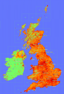
In a similar vain to the maps produced here, now that Geograph British Isles has a view counter for each and every photo, we can plot maps of viewing. :)

This map is obviouslly heavily influenced by where photos have actully been submitted; s for comparison here is a depth map of photo submissions.

Don’t know what it means, or if actully useful, but sure is pretty!


(click the thumbnail to see 1px per km scale version)

Run (& Develop) Geograph locally!

Saturday, December 13th, 2008

I’ve prepared a VMware virtual machine, that contains a ready to run instance of Geograph (British Isles). This was primarlly for my own purposes as my current working copy runs on windoz, so didn’t replicate fully the real enviroment. Now I can still run my IDE on windows, but have the code running in a almost totally faithful copy. 

The compressed image is available from:

Geograph Torrents Downloads (346.62 MB)

Requirements to run the image:

  • WMware workstation or WMare player
  • a 7z uncompression tool (apparently the best compression method for VM images)
  • At least 3GB diskspace (the image’s disk uncompressed needs 2GB – but could expand to 10GB)
  • web-browser (to actully view something) 
  • A smattering of linux know-how (to actully login and view the files – also to try changing things) 
  • To do anything useful, experience with PHP, mySQL and website development in general, is a big bonus

The image’s application database is empty – it contains no photos or other data from Geograph British Isles, other than the bare minimum to get running (but contains the non-copyrighted BI geodata for map plotting etc). If you want a developers dump to try loading some real data please get in touch with the team. 

Hopefully this should be a real quickstart way to get a local working copy running – ready setup with required software, cronjobs etc – ideal for:

  • Just finding out more about how the site works :)
  • Doing real development work – with the aim to contribute back (its ready setup for easy SVN commits) 
  • To customise the code for a new country! (we have plans to make this even easier)

(NB. only torrent download currently available – others probably available on request)

Enjoy!

MGRS coordinate entry

Friday, December 12th, 2008

Prompted by one of those infernal* posts on a Google Maps group, have finally been inspired to cobble together a MGRS -> Lat/Long conversion. It seems trvial, the UTM->MGRS conversion is quite simple, but there are a few gotchas!, so after much puzzleing over some C code from GeoTrans (and Trial&Error for good measure!), I think** have something working.

Anyway try it out here: 

Coordinate Flyto for Google Earth/Maps

also added today is a tickbox to open the result direct in Google Maps (rather than Google Earth). 

I’ll tidy it up and post the code, which is based on the PHPcoord conversion class, incase others have a use. I’ll also add it to the API – and possibly even back port it into Perl for use on the on site coordinate covertor. 

Finally possibly of interest is the realisation that the MGRS Google Earth Gridlines layer, will actully load directly in Google Maps, so:

MGRS Gridlines in Google Maps

the lines should update a few seconds after dragging/zooming. Ideally will suppress the big blue pins (which are show as numbers in GE) , but not tonight…


* in the nicest possible sence!

** I tested it by converting utm->mgrs->utm globally on a worldwide 1 degree grid – all check out with absolute precision.
How Geograph survived the BoingBoing effect…

Sunday, October 19th, 2008

… so its 1am on an idle Wednesday (and you really thinking of heading to bed) when someone on the forum mentions the 1 millionth photo will be going soon, so you think Na, its too early, but out of interest you go and check anyway… And you find in fact its right there about to go in a matter of seconds (going on moderation time) … and then you exclaim,

oh carp, oh carp, oh carp (or words to that effect)

… why do I say that? Well the thing is I know that Geograph runs pretty close to the limit* hosting wise, and this milestone, could, should and probably will, make a big splash, suddenly have mental images of Geograph exploding in a fireball, … not good!

(note, the rest of this post uses a few technical terms, and is rather long, turn away now if that scares you…)

(more…)

My Maps Container

Wednesday, August 6th, 2008

When using the Google’s My Maps feature you can display multiple maps at once simply by ticking the boxes, however the ‘Link to this Map’ will only ever include 1 map, so you can’t easily send a group of maps to someone.

… So a new script – this time under the gokml.net banner – for creating a ‘container’ KML that simply opens a bunch of maps at once – this KML is openabe in Google Earth, but also you can share the link so others can see your batch of My Maps at once in Google Maps.

Create a KML container for a group of My Maps


As a total aside I notice My Maps, now sport a (Geo)RSS feed :)

Google Earth: Chart Plotter

Sunday, July 27th, 2008

Did someone mention a chart plotter? If so have a look-see:

Google Earth: Map Plotter

Its hot off the presses so don’t know what options it will need yet, just used three example zooms levels – other options would include the mobile map style. (You can change it by altering the link in Properties)

Also its standard Google Maps, as that is all the API offers. Ideally would be proper flight plan data, but would need a Static Map API to work.

Note: The map is centered on the camera position (so is ideal for the Flight Simulator) – and while it can be used in other modes it wont make much sense. If interest could make one that shows the center of the view itself.

Disclaimer: this is entering the gray area of what is possible with the Static Maps API, so might get pulled, etc.

More flight sim tools

Google Earth: Flight Simulator GPS Arrow

Saturday, July 26th, 2008

Behold a new network link from nearby.org.uk:

Google Earth GPS

Once you have chosen a destination point, a small arrow will be shown in the bottom right of your Google Earth window, which points towards your destination! Ideal for use in the flight simulator, where you can play follow the arrow.

Note it only updates every 5 seconds, and comes with all sorts of disclaimers such as don’t use in life or death situations.

Search along a route

Tuesday, July 22nd, 2008

As a very rough, but somewhat nifty, proof of concept have created a little page, that answers (or attempts to!) the old age question of “Where is the best place to stop off for pizza along my route?”

Search along a route

as mentioned its very approximate, the search alogorithm is crude, I am certain there are better ways of doing it, anyone fancy taking it on?

Geograph by Bittorrent!

Tuesday, July 1st, 2008

Lordelph has just setup a new system to distribute the Geograph archive by bittorrent! For this to work really well we need as many people to help seed as possible, so if you are able please do!

I have a number of servers sitting around that could help with this, so I am particularly keen to have a client that can be setup on linux boxes easy, Lordelph pointed me towards rtorrent which so far seems to be working well. I don’t have time to document it fully now, but below is a quick start guide to what I did to get it going (on Fedora, other flavours very similar), with minimal fuss. The next step will be to have a script to automatically discover new torrents.

#install rtorrent (using yum as fedora)
yum install rtorrent

#create user and folder
adduser geotorr
mkdir /var/geotorr
chown geotorr:geotorr /var/geotorr

#setup initial enviroment
su geotorr
mkdir /var/geotorr/session
mkdir /var/geotorr/watch
cd /var/geotorr/watch/
wget http://torrents.geograph.org.uk/torrents/geograph_vol001_image_0_to_49999.torrent

#create config file (setting up to use created folder, and to setup watch and session folders)
# paste in the example from http://libtorrent.rakshasa.no/browser/trunk/rtorrent/doc/rtorrent.rc?rev=latest and edit
# or see my version available at http://barry.pastebin.com/f6f861f59
nano ~/.rtorrent.rc

#but see also (haven't read it myself!)
# http://kmandla.wordpress.com/2007/05/02/howto-use-rtorrent-like-a-pro/

# then to add new torrents in future just drop the .torrents files in the watch folder
# - a little script that follows that RSS feed would do nicely here!

more… on the geograph forum.

Edited Tues PM for spelling and grammar – the previous post wasn’t proof-read!

Piclens viewer for Geograph

Thursday, June 19th, 2008

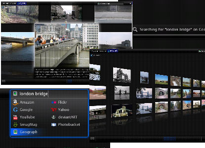
Piclens is an amazing program for very simply viewing photos full screen, in a fluid browser plugin, minimising distractions to focus on the photos. Really you have to try it for yourself to experience it, but below are a few screenshots, I highly recommend downloading it yourself, works on Internet Explorer, Firefox 2 and 3 amongst others. Even more interesting is thanks to the team at Piclens we have a special version that incorperates a Geograph search, so download Piclens using the special link below:

http://download.piclens.com/partner/aT78rK8wv9ML

If you already have it, it might ask to reinstall again.

Piclens screenshots
(click to enlarge – my graphics skills don’t do it justice)

Also of note the search box uses Geograph’s new experimental full text engine, so should be quick and intuitive to use… Also when viewing the search results, continues rightwards in a continuous 3D wall – no paging required.

As expected the piclens display page on Geograph still works, which can be used to visualise any standard results. Choose the ‘piclens’ option using the dropdown on the search page.