Multi Destination Routing + Altitude Profile

May 8th, 2009

There is a tool on nearby for taking a multi destination route – and loading it into Google Earth. It was also used to load directions into a “My Map”, but thats basically redundant now, but as the script just converts the directions to a KML file, there are many useful things that can be done with it…

Such as plotting an altitude profile with gpsvisualizer.com***, but to make it even easier, have added a button to the page, that links direct to the form on gpsu with the data prefilled as well as the ‘add altitude’ option enabled.

Enjoy! (Oh and let me know if there are any other interesting destinations would like to load the KML file into!)

Multi Destination Routing Toolkit

*** which Adam recently added the functionalty to add alitude automatically – previsoully a problem as the KML files from Google maps dont include altitude

Where in British Isles are people viewing photos?

April 24th, 2009

view-depth1-9
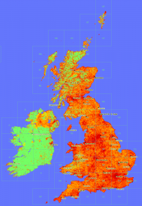
In a similar vain to the maps produced here, now that Geograph British Isles has a view counter for each and every photo, we can plot maps of viewing. :)

This map is obviouslly heavily influenced by where photos have actully been submitted; s for comparison here is a depth map of photo submissions.

Don’t know what it means, or if actully useful, but sure is pretty!


(click the thumbnail to see 1px per km scale version)

Directions to My Maps finally!

April 23rd, 2009

Google has just added a new feature to Google Maps to save a set of directions into a My Map! This makes obsolete a popular script on ere :)

But they have gone a step further! This screenshot probably explains it best

nice.

(via)

Warning: it seems the ‘Save to My Maps’ overwrites the previous content of a My Map, not append like I would expect :(
Edit: maybe its only temporally, if it happens to you, try disabling and reenabling the map – see comments.

is it ScenicOrNot?

April 4th, 2009

ScenicOrNot

ScenicOrNot is a new mashup from the good people at mySociety – with the simple aim of finding the scenic spots across Great Britain; I’ve no idea what the super secret purpose of this site is, but they have promised to release the data, so it could be used in lots of exciting ways… 


Oh and of course the photos are sourced from Geograph British Isles.

Go rate a grid square now! Also at http://digg.com/u18iG

URLsnipper for Google URLs

March 31st, 2009

I am often copy/pasting links to Google searches – particully on Google Maps. Nearly every time I have to hand edit the URL – mainly as I KNOW a large proportion is redundant. Quite frankly a long url is scary, and others know it too. 

Anyway so I created a little script for my own use to cut down the URL automatically:

URLsnipper for Google URLs

It has a good understanding of Google Maps URLs, and reasonable for Google Web search, so it makes a fair attempt at deducing unneeded bits, however it also provides tickboxes to truely customise the result to your own taste :)

Example (a fairly mundane one)

will add support for other urls at some point, blogsearch, news etc. 


Partly inspired by this

looking for Atlantis…

February 20th, 2009

There is lots of hype of Atlantis being found found in Google Maps, and while its clear its NOT Atlantis itself, maybe it is evidence of someone searching for it… 

The path followed by the ship is regular, as though its a search grid?

The question is did they find something? And the Sun exposee is just a coverup for the real discovery – hide something in plain sight and all that…


:-P

Leaky and verbose URL parameters…

February 18th, 2009

Disclaimer: this post is a rant – turn away now!

I can’t keep quiet about this any longer, its getting me more and more annoyed. Google Maps includes a “Link” function – which creates a link to the current map, which is very useful – particully as the map is estentially ‘ajax’ style, but the parameters are definitly starting to suffer rot and lack of ‘love’ in maintaining them.

For example to just display a simple KML file, you get this corker:

http://maps.google.com/maps?f=q&source=s_q&hl=en&geocode=&q=http:%2F%2Fwww.geograph.org.uk%2Ffeed%2Frecent.kml&g=Any+Street,+London,+UK&ie=UTF8&ll=55.053203,-3.208008&spn=17.762194,33.793945&z=5

There are so many things wrong with this url, its unreal. The first is the source – doesnt do
anything as far as I can see, an empty (but immensely useful) geocode, etc; but somewhat ironically I have HAD to edit the url provided by the function before I was willing to post it here, see that g param – yes that’s my (now made up!) home address.

Yes thats right, if you not careful Google Maps might get you to inadvertently share your home address – seriouslly WTF!

Read the rest of this entry »

Geograph Germany (quietly) launches!

February 18th, 2009

It’s very nearly happened a number of times before, but its now offical we have the first Geograph website for another country! 

This is the though the hard work of Hansjörg Lipp, fighting though the various land mines we have left in the open source code that powers geograph. As developers we (well mainly me – I am a lazy programmer!) have taken a number of shortcuts it just getting it to work the quickest way for us in the British Isles, so while the intention its should be easy to start another country it was never as easy as it should be.

You can see the site here:

http://geo.hlipp.de/

which will hopefully be translated fully to Germany. There is also a English language version here:

http://geo-en.hlipp.de/

which still connects to the same database :)

You can read about the experience of working with the code here :)

Its still early days for the project (it only covers a few provinces of southern Germany so far), but its really exciting to see a new site based on the Geograph concept (and code!), we wish Hansjörg Lipp and his team every success. (I wont embarrass myself trying to put any German in here!)

Ask the audience… how to promote long term seeding?

February 6th, 2009

Geograph offers bulk Torrent downloads, of images. All good (we hope!), but a major reason for doing this is to utalise the power of p2p and share the bandwidth bill. We have bordering on 150Gb of image data to share, but everybody downloading that data from our servers is, well a LOT, not to mention slow, and using bandwidth that could otherwise be serving regular visitors. (the alternative is to serve it from home – but using the upstream connection for that size is also really slow…) 

But to do this is needs others to help with the seeding – in the long term. For a while now 90% of downloading is coming from a seed I have on a server, ie people are peering while downloading, but as soon as the download is completed… its ‘thanks for the fish’ and they are gone.

(we could seed from our homes too, but with the server offering a big enough pipe theres no need – yes aware of the irony in that statement – but we already paying for the server) 

So what can be done to help encourage others to stick around and help?  One consideration is the torrents include the raw files – rather than a tar or similar, making it easy to keep the torrent software pointed at the folder that actullly use the images – without duplication. 

What if the files where made smaller?  (but would mean many more torrents – and the assumption is people are pretty much wanting most images, so picking and choosing isnt really going to happen) 

One critism is the metadata in the files, is hard to keep uptodate – the metatdata is updated on the site from time to time. But for the most part that can be considered a different issue, we can offer bulk downloads of data – on a bespoke basis. (and have an API

I’ve looked around the interweb, and this does crop up occasionally. But our case is somewhat unique; its a specialist market (so really at most 1 or 2 downloaders at once), the files on the large size, and we’er in this for the long term (decades ideally!).
Flight Simulator Recorder! (for real)

February 2nd, 2009

The new tour recording function introduced in Google Earth version 5, actually makes the ‘black box recorder’ I created a while ago, obsolete now :)

While in Flight Sim mode, hold down Ctrl and Alt and press B. Then right click somewhere in places and goto ‘Add’ and choose Tour. Then you can hide the sidebar by pressing the same combination again. Now press the record button and fly away!

Click the Record button to stop recording – dont forget to click the little disk icon if want to save the recording to Places. 

Tip. Right click the Tour in your places tree, and select Copy. Then paste into a texteditor (eg Notepad) and you can see the raw KML recording. 


If you have any recordings from my Recorder. You should be able to download the linestring, and click the little Tour icond beside the opacity slider, to playback. And while playing you can be recording it into a real ‘Tour’ for.

I’m just shamefaced I’m not a good enough pilot to feel confident in posting any of my recordings…. 


(I think this is probably the last post I will make for now, this is the fourth about the new version 5!)